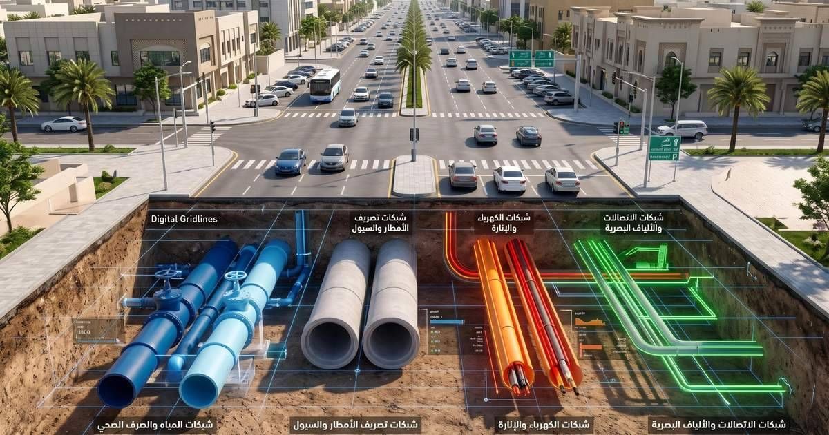
هذا الاستبيان جزء من دراسة ماجستير في الجامعة الإسلامية بالمدينة المنورة عن إدارة المخاطر في مشاريع البنية التحتية في المملكة العربية السعودية، وكيف يمكن لنمذجة معلومات البناء (BIM) أن تقلل تجاوز التكلفة وتأخير الجدول الزمني. يستغرق الاستبيان حوالي ١٥ دقيقة. المشاركة تطوعية، ويمكنك التوقف في أي وقت. لا نطلب اسمك ولا اسم جهتك، وتُعرض الإجابات كنتائج مجمّعة فقط. بمتابعتك للاستبيان فأنت توافق على المشاركة.
This survey is part of a master's study at the Islamic University of Madinah on risk management in infrastructure projects in Saudi Arabia, and how Building Information Modeling (BIM) could reduce cost overruns and schedule delays. It takes about 15 minutes. Taking part is voluntary, and you can stop at any point. We do not ask for your name or your company's name, and all answers will be reported only as group results. By continuing, you agree to take part.
عن ماذا يتحدث هذا الاستبيان؟
يتناول الاستبيان مشاريع شبكات البنية التحتية تحت الأرض، مثل شبكات المياه، والصرف الصحي، وتصريف الأمطار، والري، والكهرباء، والاتصالات، والإنارة، وأي شبكات أخرى مشابهة لها، وهي شبكات تُنفَّذ عادة داخل الطرق ومع أعمال الطرق.
ما هي نمذجة معلومات البناء؟
طريقة عمل تُرسم فيها هذه الشبكات والطرق في نموذج رقمي ثلاثي الأبعاد (3D) قبل التنفيذ. يحتوي النموذج على تفاصيل الشبكات مثل: الموقع، والعمق، والقطر، وغيرها من المعلومات، بدل الاعتماد على المخططات ثنائية الأبعاد (2D) فقط.
كيف تساعد في هذه المشاريع؟
نقصد بها في هذا الاستبيان أربعة استخدامات:
١. كشف التعارضات قبل التنفيذ، مثل تقاطع خط مياه مع كابل كهرباء، أو غطاء منهل لا يطابق منسوب الطريق.
٢. نمذجة الشبكات القائمة والمنفذة، لمعرفة مواقعها قبل الحفر وتجنب إتلافها.
٣. تخطيط تسلسل التنفيذ بربط النموذج بالجدول الزمني، لتجنب الأخطاء مثل الحفر بعد الأسفلت.
٤. حصر الكميات وتقدير التكلفة من النموذج.
What is this survey about?
This survey is about underground utility network projects, such as water, sewage, stormwater drainage, irrigation, electricity, telecommunications and street lighting networks, and any other similar networks, which are usually built within roads and alongside road works.
What is Building Information Modeling (BIM)?
A way of working in which these networks and roads are modeled in a 3D digital model before construction. The model contains network details such as location, depth, diameter and other information, instead of relying on 2D drawings alone.
How does it help in these projects?
In this survey, BIM refers to four uses:
1. Detecting clashes before construction, such as a water line crossing an electrical cable, or a manhole cover that does not match the road level.
2. Modeling existing and installed networks, to know where they are before excavation and avoid damaging them.
3. Planning the construction sequence by linking the model to the schedule, to avoid mistakes such as excavating after asphalting.
4. Taking off quantities and estimating cost from the model.